Advanced techniques in mining geophysics – An interview with Kellwi Tejada
The interview focuses on the experience of Kellwi Tejada, who is the head of geophysics at Anddes, and addresses the main geophysical techniques used in mining projects. Techniques such as seismic prospecting, geoelectrical prospecting, and other tools such as ground-penetrating radar (GPR) and transient electromagnetics (TEM) are discussed. Techniques such as electrical resistivity tomography, the 2D MASW test, and seismic refraction tomography are highlighted as the most effective for characterizing the foundation soil and mining components.
What are the main geophysical techniques that you have used in mining projects, and which do you consider most effective for applications in the mining industry?
I believe my experience as a geophysical engineer is focused on applied geophysics in terrains up to depths of ≤100 m, which allows you to obtain high-resolution and precision data to make the best decisions in different engineering studies in mining.
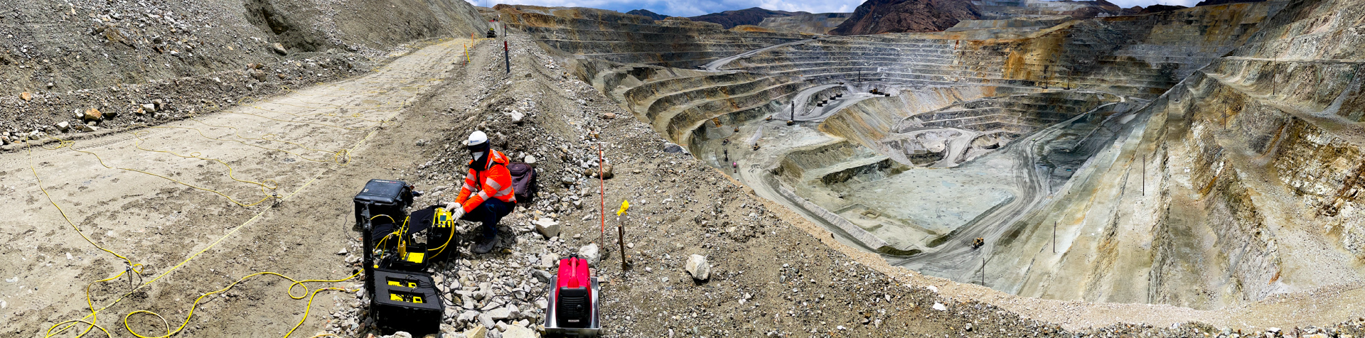
The techniques I have put into practice the most, due to their degree of reliability and feasibility, are those found in the group of seismic prospecting tests such as seismic refraction tomography, seismic reflection, surface wave tests such as MASW1D/2D, passive seismic tests such as multichannel analysis of microtremors and the H/V spectral ratio test; likewise, I have the experience to carry out vibration tests for blast monitoring and borehole seismic tests (Down hole, Cross Hole and Up Hole). I also continuously apply geoelectric prospecting tests, such as electrical resistivity tomography, induced polarization, natural and induced electrical potential measurements, electromagnetic tests such as ground penetrating radar (GPR) and transient electromagnetics (TEM), each of them for a specific purpose.
Among the techniques that I consider most effective of all those already mentioned are 2D and 3D electrical resistivity tomography, the MASW 2D test, seismic refraction tomography, borehole seismic and GPR. All these techniques are oriented to characterize the foundation soil and the body of the mining components, in order to be able to detect any danger in the stability and integrity of the structure.
Could you describe a specific challenge you have faced when applying geophysical techniques in a mining environment and how you solved it?
I remember once working in an environment with a lot of heavy vehicle traffic and production plants that generated abundant ambient noise, which prevented us from obtaining good seismic data. I solved it by applying new passive seismic techniques such as the Multichannel Analysis of Microtremors (MAM) test, where the test records ambient noise signals that were abundant in that place and that allows characterizing the subsoil with good results. A new test plan had to be carried out to achieve the objective, but this time guaranteeing good results. This makes us understand that geophysical methods adapt to any environment or situation very easily, probably not all will be useful because they have their advantages and disadvantages, but at Anddes we have a wide variety of equipment and tests that allow us to provide a quick solution to different problems.
How do you determine which geophysical technique is most suitable for a specific mining project, considering factors such as soil type, depth, and lithology?
Several aspects must be considered. First, I identify the purpose of the study, the depth of investigation to be achieved, the conditions of the terrain to be explored, and general aspects of the local geology. According to these initial considerations, I choose the most suitable technique for carrying out the prospecting. For example, if my objective is to determine the thickness of the stratum that contains abundant moisture or a high water table (wetland), I could not use seismic refraction because the presence of water distorts the arrival of the P-waves; for this situation, I use electrical resistivity tomography, which characterizes this type of soil very well, since the electrical current manages to transmit easily in this medium. On the other hand, if the objective is to characterize the type of rock based on wave velocities, the most convenient test is seismic refraction or MASW2D, which has an active source; in that sense, the MAM test could not be applied because in this type of very rigid material, the phenomenon of wave dispersion by passive sources does not occur.
What is your approach to the acquisition and processing of geophysical data in mining projects, especially in areas with adverse or difficult-to-access conditions?
The key is to know the environment where you are going to explore very well. For this, it is essential to make a technical visit to the project before executing the geophysical tests. This will allow us to locate the best sectors of the land so that the test provides good quality data; but that is not enough, you also have to evaluate the characteristics of the geophysical equipment, such as the source, the power, the sensitivity of the instrument, the geometric arrangement to be used, among others. All these aspects will help to be successful in the prospecting and processing of information, for which it is necessary that the assigned personnel have the necessary experience to address these situations.
How does the interpretation of geophysical data contribute to the planning and decision-making in the development of a mining project?
I think that geophysical interpretation has a fundamental role in the planning and decision-making of a mining project through the evaluation and management of risks associated with mining activity, such as the stability of the land, the contamination of groundwater and the identification of areas of geological – geotechnical risk.
The use of geophysical techniques not only benefits mining companies in the development of their engineering projects, but also the environmental and social surroundings. For example, geophysical prospecting helps to characterize large areas of land in a precise, efficient, and non-invasive way, optimizing the need to carry out a significant number of invasive exploratory drillings, which reduces costs and the environmental impact associated with subsurface prospecting. Finally, all these benefits offered by geophysical prospecting promote more efficient management of natural resources, thus contributing to the preservation of ecosystems and the sustainable development of communities near mining operations.